I regularly use four different iOS mapping applications. They all have their advantages.
Google Maps, the built-in app, is excellent. The integration with transit schedules in many cities is awesome. It’s main weakness is that it requires a data connection, so I use it very little in foreign countries where data costs are exorbitant. I would like to see the option for ‘+’ and ‘-‘ buttons to zoom in and out: The pinch gesture is awkward to use with just one hand, such as when holding something in the other hand, or riding a bike. I would also like the option to display alternative routes, just like in the Google maps website.
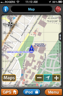
MotionX GPS is my main mapping application when I switch data off, or when I want to track my path or a set of waypoints. One can pre-load maps, at different resolutions, for places one intends to visit. It has a whole host of other features that also prove useful from time to time. Its most annoying issue is the splash screen that appears on startup. Its second-most-annoying issue is that when you select a waypoint and ask to show the map for that waypoint, you cannot keep the map at that waypoint. You are in a mode where you have to select 'done', after which the map jumps back to where it was. I have also found the detail in maps to be weak in some rural areas. It does have the ‘+’ and ‘-‘ buttons for zooming that I find very useful for one-handed operation. Hint: Learn what the 'zoom level' numbers mean; these appear at the bottom-right of the map. Knowing these numbers, and the amount of detail corresponding to each, will help you when pre-loading maps.
Topo Maps is excellent for detail when hiking in rural areas. As with MotionX GPS, one can pre-download the maps of the areas one intends to visit. It currently covers only North America though, and it is of little use in urban areas since there are no street names and the maps are older government-issue official maps.


No comments:
Post a Comment
Note: Only a member of this blog may post a comment.